Monitoring for Environmental Impact Assessment
Fill the data gaps left by traditional monitoring surveys – accelerate approvals and minimise dalays.


Trusted by industry leaders


Reduce Biodiversity Risks for Future Wind Farms
Challenge
Traditional surveys deliver fragmented, weather- and daylight-dependent data that leads to additional studies, permitting delays, and regulatory risks.
Solution
A buoy-mounted camera system integrated with a metocean/LiDAR campaign, delivering more than 4,500 hours of daytime monitoring per year in all weather conditions, with species-level and flight-height data.
Outcomes
- Species-level insights that strengthen EIAs and de-risk approval
- Clear visibility into migration peaks and seasonal dynamics
- Flight-height distributions for robust risk modelling
- Stronger auction bids with credible, high-resolution video evidence and data reports
- Greater certainty for developers, regulators, and stakeholders

Richer Data for Environmental Compliance
Traditional surveys in the UK monitor
- Daylight & weather dependent
- Activity outside monitoring hours and nocturnal activity remains unmonitored
- Visual height estimates introduce error margins that overstate risk
Spoor in the daytime monitors
- Operates in all weather conditions
- Monitoring from dusk till dawn – night time monitoring available
- Consistent automated species-level detection
- Site-specific rotor-zone data with precise flight height
- Structured data is available in the Sky Intelligence Platform, ready to be used for collision risk modelling
AccelerateAcceleratepermitting,permitting,preventpreventdelaysdelaysfromfromdesigndesignchanges,changes,andandminimiseminimiseunnecessaryunnecessarycurtailmentcurtailment
Bird and Bat Activity Monitoring
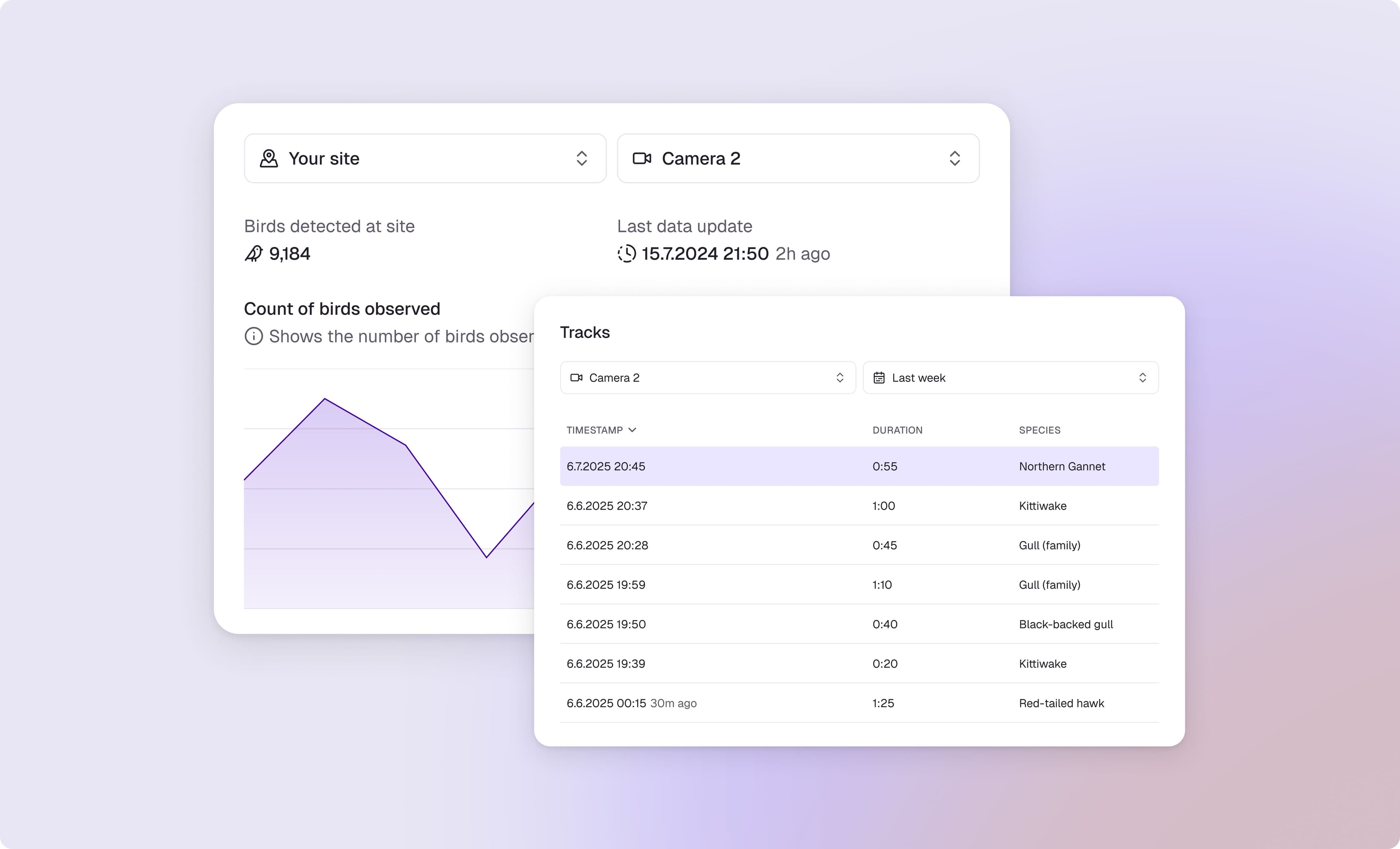
Continuous, automated detection and classification of birds and bats activity at a site turning video footage into a structured dataset. Key capabilities:
- Detects birds and bats in the detection zone, incl. counts, speed, flight height, direction, presence at micro- and meso- scale
- Saves every detected flight as an annotated track video and image, with the flight path overlay and zoomed thumbnails to support species verification
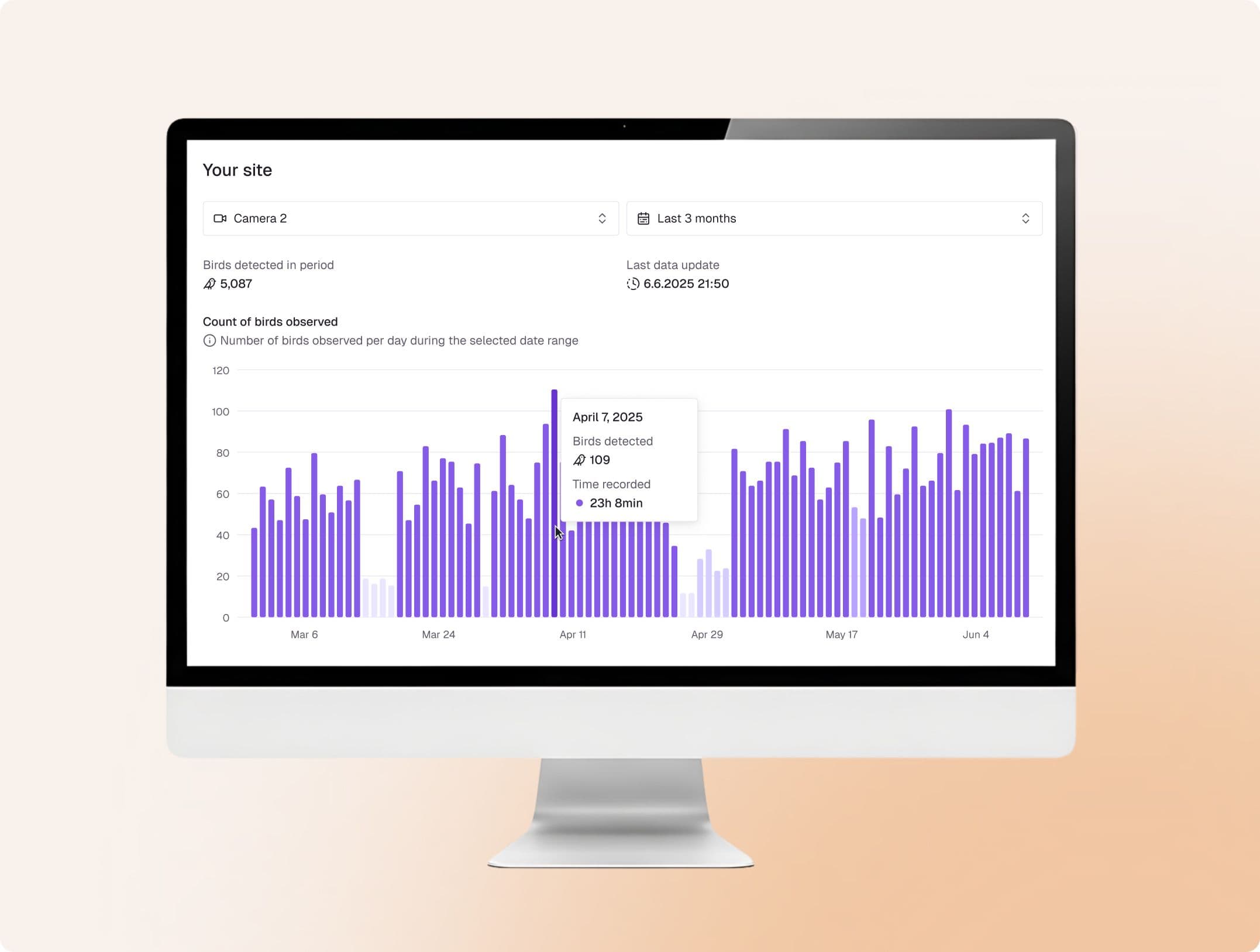
- Produces metrics on detection counts, hourly activity profiles, observation rates, flight directions, and altitude bands
- Correlates activity with metocean and wind farm parameters, such as wind speed and direction, turbine status, its speed, design and layout
Data Consumption via Sky Intelligence Platform
Monitoring, AI detection, human validation, and contextual modelling are unified in a single platform – supporting decisions across the full wind farm lifecycle.
- Analytical support via correlation with weather, radar and historical bird activity data
- Report-ready tables and figures for EIA submissions
- Easy data exports for consultants and regulators

“This will greatly improve our understanding of collision risk and strengthen impact assessment.”
Aonghais Cook
Senior Principal Consultant at The Biodiversity Consultancy
“It has provided us with a reliable record of bird activity around offshore assets that cannot be achieved with traditional survey methods.”
Rob Iredale
Ornithology Manager at Ocean Winds
Pre-installation Buoy Monitoring at Hywind Tampen
Mounted on Fugro buoy, the system demonstrates high performance capability in all weather conditions, proving the feasibility of AI-driven biodiversity monitoring at deep-sea sites.

Report
Pre-installation Buoy Monitoring at Hywind Tampen: A Review by The Biodiversity Consultancy

Featured Collaborations and Customer Stories
Spoor partners with leading consultancies, infrastructure providers, and OEMs worldwide to scale smarter wildlife monitoring. The aim of each project is to help developers reach their permitting, delivery, and biodiversity goals.
Spoor's AI-powered bird monitoring integrates directly onto Fugro's buoys, enabling developers to add continuous bird activity data to an already planned metocean campaign.

Continuous monitoring at Vattenfall's Aberdeen Bay offshore wind farm tracked over 137,000 birds in 19 months and recorded zero confirmed collisions, with observed risk roughly 7,000 times below predictions.

WISE Group brings its offshore operations experience to the partnership, with the system design, installation, and operational expertise needed to deliver reliable monitoring in the most demanding offshore and onshore conditions.
What is next?
- 1Scope the project around regulatory requirements
- 2Collect data and combine it with wind and turbine data for full context
- 3Export datasets for environmental consultancies and regulators
- 4Stay compliant while reducing biodiversity risk

Reduce Biodiversity Risks with Spoor
Talk to one of our experts to find the best solution based on your needs.